Location | |
| Country | China, India, Pakistan (Sovereignty in the Kashmir region is disputed.) |
| States or provinces | Tibet Autonomous Region, Ladakh, Gilgit-Baltistan, Khyber Pakhtunkhwa, Punjab, and Sindh |
| Cities | Leh, Kargil, Skardu, Dasu, Besham, Thakot, Swabi, Dera Ismail Khan, Mianwali, Bhakkar, Sukkur, Hyderabad, Karachi |
Physical Characteristics | |
| Source | Lake Manasarovar |
| • location | Tibetan Plateau |
| Source confluence | |
| • location | Shiquanhe, Ngari Prefecture, Tibet Autonomous Region, People’s Republic of China |
| • coordinates | 32°29′54″N 79°41′28″E |
| • elevation | 4,255 m (13,960 ft) |
| Mouth | Arabian Sea (primary), Rann of Kutch (secondary) |
| • location | Indus River Delta (primary), Pakistan Kori Creek (secondary), India |
| • coordinates | 23°59′40″N 67°25′51″E |
| • elevation | 0 m (0 ft) |
| Length | 3,180 km (1,980 mi) |
| Basin size | 1,120,000 km2 (430,000 sq mi) |
| Discharge | |
| • location | Indus Delta, Arabian Sea, Pakistan |
| • average | 5,533 m3/s (195,400 cu ft/s) |
| • minimum | 1,200 m3/s (42,000 cu ft/s) |
| • maximum | 58,000 m3/s (2,000,000 cu ft/s) |
| Discharge | |
| • location | Sukkur |
| • average | 5,673.486 m3/s (200,357.3 cu ft/s) |
| Discharge | |
| • location | Mithankot |
| • average | 5,812.326 m3/s (205,260.4 cu ft/s) |
| Discharge | |
| • location | Tarbela Dam |
| • average | 2,469 m3/s (87,200 cu ft/s) |
Basin Features | |
| Tributaries | |
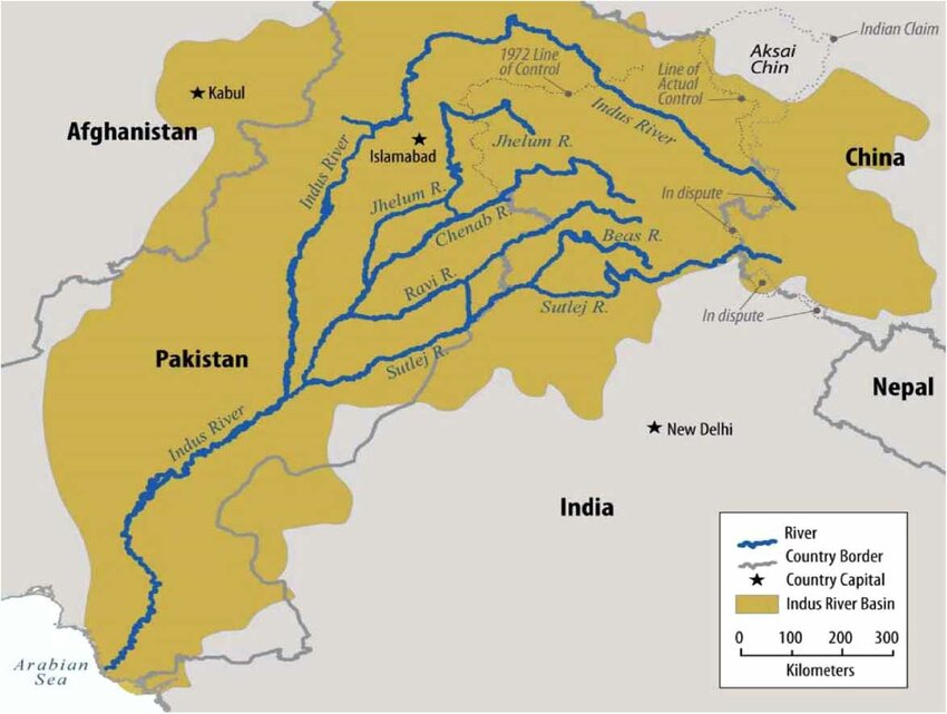
| • left | Zanskar River, Suru River, Soan River, Panjnad River, Ghaggar-Hakra River, |
| • right | Shyok River, Hunza River, Gilgit River, Swat River, Kunar River, Kabul River, Kurram River, Gomal River, Zhob River |
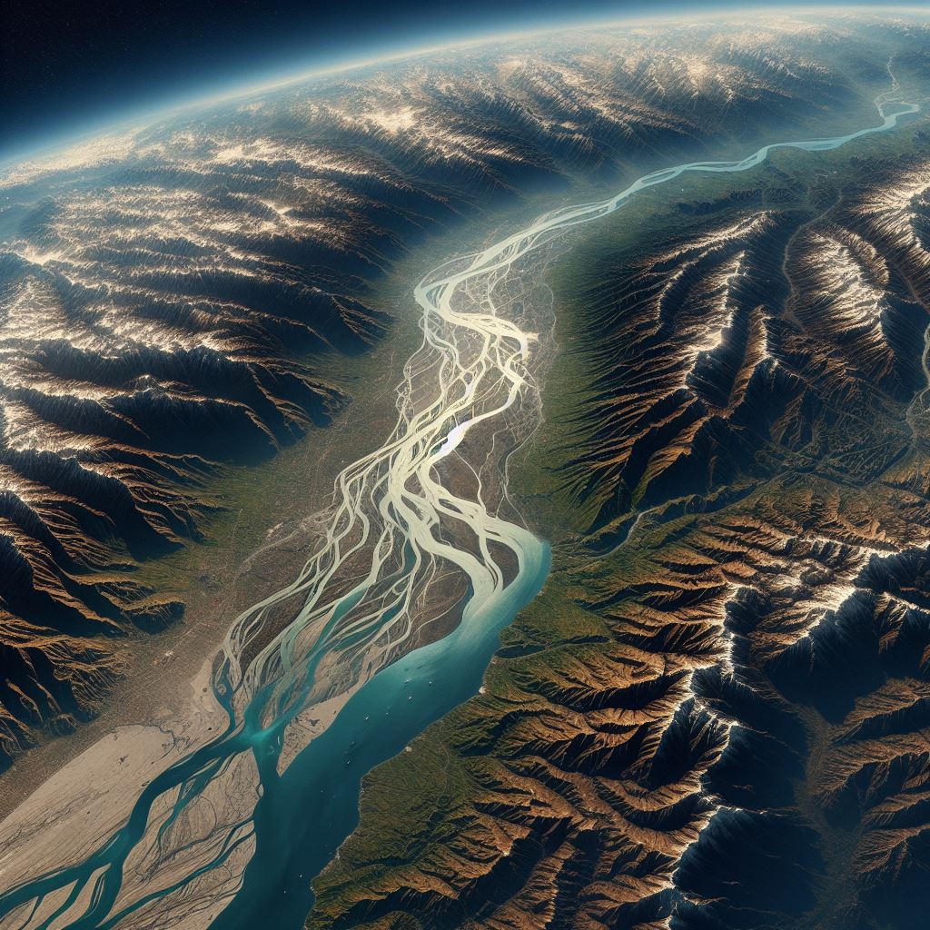
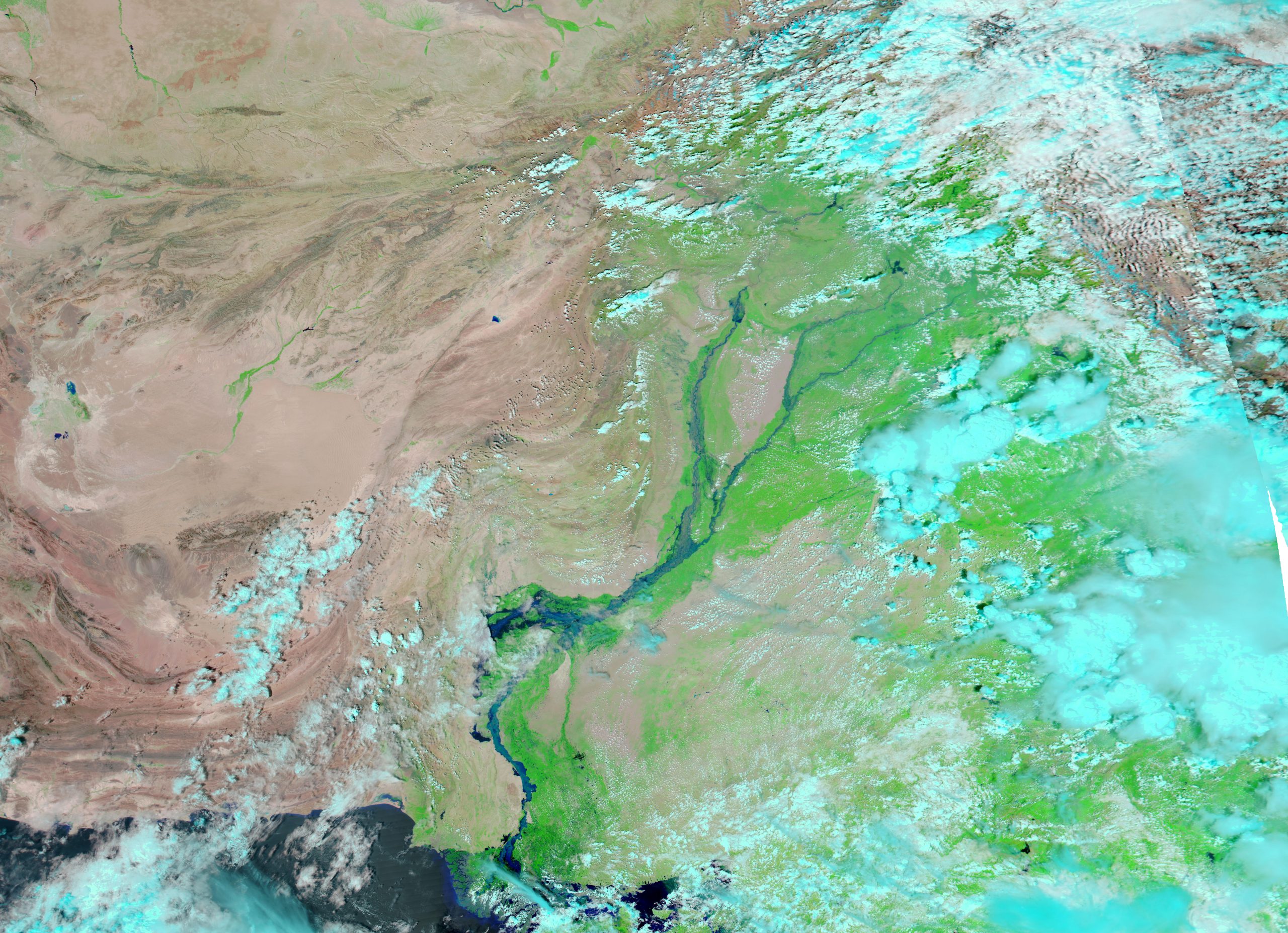
The Indus is a cross-border river in Asia, traversing the trans-Himalayan regions of South and Central Asia. Spanning a length of 3,120 km (1,940 mi), it originates from mountain springs northeast of Mount Kailash in Western Tibet. The river flows northwest, passing through the disputed Kashmir region, takes a sharp left turn beyond the Nanga Parbat massif, and continues south-by-southwest through Pakistan until it reaches the Arabian Sea near Karachi.
Covering a vast drainage area of approximately 1,120,000 km2 (430,000 sq mi), the Indus boasts an estimated annual flow of about 243 km3 (58 cu mi), ranking among the 50 largest rivers globally in terms of average annual flow. In Ladakh, its left-bank tributary is the Zanskar River, while in the plains, the Panjnad River on the left bank is formed by the confluence of the five Punjab rivers: Chenab, Jhelum, Ravi, Beas, and Sutlej. Notable right-bank tributaries include the Shyok, Gilgit, Kabul, Kurram, and Gomal rivers. Originating from mountain springs and nourished by glaciers and rivers in the Himalayan, Karakoram, and Hindu Kush ranges, the Indus sustains diverse ecosystems, encompassing temperate forests, plains, and arid landscapes.
The northern portion of the Indus Valley, along with its tributaries, constitutes the Punjab region in South Asia. The river’s lower course concludes in a vast delta in the southern Sindh province of Pakistan. Throughout history, the Indus River has held significant cultural importance for the region. In the 3rd millennium BCE, the Indus Valley Civilization, a major urban civilization of the Bronze Age, flourished along its banks. The Rigveda hymns referred to the Punjab region in the 2nd millennium BCE as Sapta Sindhu, and Avesta religious texts termed it Hapta Həndu, both signifying “seven rivers.” Early historical kingdoms, such as Gandhāra and the Ror dynasty of Sauvīra, emerged in the Indus Valley. The Western world gained knowledge of the Indus River during the classical period when King Darius of Persia dispatched the Greek explorer Scylax of Caryanda to explore the river around 515 BCE.
The Indus River is like a big storybook of nature and people. Long ago, ancient cities like Mohenjo-Daro and Harappa grew beside its waters. The river helped these places with trade, farming, and sharing ideas. It has been important for a very long time, shaping the lives of many people. The Indus is still vital today, helping millions of people by providing water and supporting different kinds of life. It’s like a living history book, connecting the past with the present and showing us how nature and people have worked together for a very, very long time.
Overview
The Indus River courses through the disputed Kashmir region, passing Ladakh and Gilgit-Baltistan, which are under the administration of India and Pakistan, respectively. This river plays a vital role in supporting Pakistan’s economy, particularly in the agriculturally rich Punjab province, often referred to as the “land of five rivers” (Jhelum, Chenab, Ravi, Beas, and Sutlej), all of which eventually flow into the Indus. The Indus not only sustains heavy industries but also serves as the primary source of drinking water in Pakistan.
The total length of the Indus varies in different sources. While this article uses a length of 3,180 km (1,980 mi) from the Himalayan Climate and Water Atlas (2015), historical records like the 1909 Imperial Gazetteer of India suggested a length of “just over 1,800 miles.” Modern publications commonly cite either 2,880 km (1,790 mi) or 3,180 km (1,980 mi). In 2011, a Chinese research group proposed an extended figure of approximately 3,600 km (2,200 mi) based on comprehensive measurements, but detailed analysis is still pending.
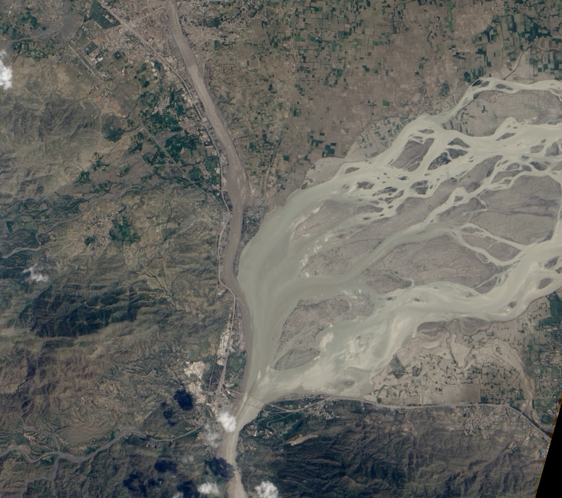
The debate about the exact source of the Indus originates in Tibet, with the traditional source being the Sênggê Kanbab or “Lion’s Mouth,” a perennial spring near Mount Kailash. However, alternative reckonings suggest the confluence of the Sengge Zangbo and Gar Tsangpo rivers further upstream. The river then flows through Ladakh and Baltistan, descending into the Punjab plains and passing through gorges near the Nanga Parbat massif. It continues through Hazara, forming the Tarbela Reservoir, and is joined by the Kabul River near Attock. The lower course winds through the plains of Punjab and Sindh, forming a delta near Thatta in the Sindh province of Pakistan.
The Indus, fed by the snow and glaciers of the Himalayas, Karakoram, and Hindu Kush ranges, exhibits a tidal bore, a rare phenomenon. The river’s flow varies with the seasons, reducing significantly in winter and flooding its banks during the monsoon months from July to September. Evidence indicates a historical shift in the river’s course, deviating westwards after the 1816 earthquake. As of 2011, Indus water flows into the Rann of Kutch during floods, breaching flood banks.
Origin and Names
In ancient Sanskrit, this river was referred to as Sindhu by the Indians, while the Persians called it Hindu or Həndu, considering it as “the border river” for both cultures. The difference in names can be explained by the Old Iranian sound change *s > h, which took place between 850 and 600 BCE, as suggested by Asko Parpola. The Greeks, during the Persian Achaemenid Empire, adopted the name as Indós (Ἰνδός), and the Romans later adopted it as Indus. The term “India” is derived from the name Indus. Various local communities have their own names for the river, such as Senge Tsangpo in Ladakh and Tibet, Gemtsuh and Tsuh-Fo among the Baltis, Nilab for the Pashtuns, and Sindhu, Mehran, Purali, and Samundar for the Sindhis. In modern Urdu and Hindi, the river is known as Sindh, a term borrowed from Sanskrit.
History & Civilization
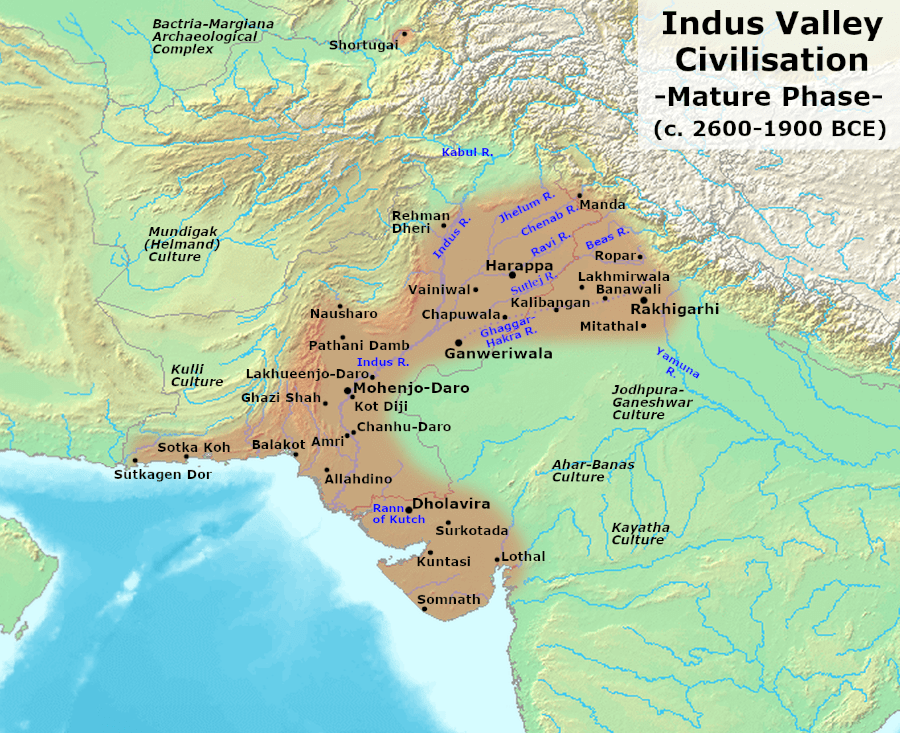
Key cities of the ancient Indus Valley Civilization, such as Harappa and Mohenjo-daro, trace back to approximately 3300 BCE, representing some of the largest human settlements in ancient times. Stretching from northeast Afghanistan to Pakistan and northwest India, the civilization covered regions east of the Jhelum River to Ropar on the upper Sutlej. Coastal settlements extended from Sutkagan Dor at the Pakistan-Iran border to Kutch in modern Gujarat, India. Notable sites include Shortughai on the Amu Darya in northern Afghanistan and Alamgirpur at the Hindon River, just 28 km (17 mi) from Delhi. Over 1,052 cities and settlements have been discovered, primarily in the Ghaggar-Hakra River region. Major urban centers included Harappa, Mohenjo-daro, Lothal, Dholavira, Ganeriwala, and Rakhigarhi. Although only 40 Indus Valley sites have been found along the Indus and its tributaries, a significant number of Indus script seals and inscriptions were discovered at these locations.
Scholars suggest that settlements of the Gandhara grave culture, associated with early Indo-Aryans, thrived in Gandhara from 1700 BCE to 600 BCE, overlapping with the decline of Mohenjo-daro and Harappa.
The Rigveda mentions rivers, including one called “Sindhu,” likely referring to the present-day Indus river. The term “India” originates from the Indus River, initially denoting regions along its east bank, encompassing present-day Punjab and Sindh. However, by 300 BCE, Greek writers like Herodotus and Megasthenes used the term to describe the entire subcontinent extending much farther eastward.
The lower Indus basin acts as a natural boundary between the Iranian Plateau and the Indian subcontinent, covering parts of Pakistani provinces and countries such as Afghanistan and India. The Persian Empire, led by Darius the Great, was the first West Eurasian empire to annex the Indus Valley. Alexander the Great’s invasion crossed the Indus, but after conquering the west bank, his armies chose to retreat along the southern course, concluding his Asian campaign. The Indus Valley saw dominance from various empires, including the Mauryan and Kushan Empires, Indo-Greek Kingdoms, Indo-Scythians, and Hepthalites. Over centuries, Muslim armies, including Muhammad ibn al-Qasim, Mahmud of Ghazni, Muhammad of Ghor, Timur, and Babur, crossed the river to invade Sindh and Punjab, serving as a gateway to the Indian subcontinent.
Geography
Tributaries
- Gar River: A tributary enriching the Indus River’s flow in the vast network of its contributing waters.
- Gilgit River: Contributes to the Indus, flowing through the scenic Gilgit-Baltistan region.
- Gomal River: Adds to the Indus waters, serving as a significant tributary in the region.
- Haro River: A vital tributary, merging its waters with the Indus and enhancing its course.
- Hunza River: Joins the Indus, bringing waters from the picturesque Hunza Valley.
- Kabul River: Contributes to the Indus, flowing through Afghanistan and Pakistan’s Khyber Pakhtunkhwa province.
- Kunar River: Enhances the Indus flow, originating in Afghanistan’s Hindu Kush region.
- Kurram River: A key tributary, enriching the Indus with its waters from the tribal regions of Pakistan.
- Panjnad River: Confluence of five Punjab rivers (Chenab, Jhelum, Ravi, Beas, and Sutlej), significantly boosting the Indus.
- Chenab River: One of the major rivers merging into the Panjnad, contributing to the Indus flow.
- Jhelum River: Joins the Chenab in the Panjnad, playing a crucial role in the Indus basin.
- Ravi River: Contributes to the Panjnad, adding to the Indus River’s overall volume.
- Satluj River: Another key river merging into the Panjnad, impacting the Indus flow.
- Beas River: Joins the Satluj, collectively influencing the Indus River.
- Chenab River: One of the major rivers merging into the Panjnad, contributing to the Indus flow.
- Shyok River: A significant river that contributes to the Indus in the Ladakh region.
- Soan River: A smaller river, adding its waters to the Indus in the plains of Punjab.
- Dras River (or Shingo River): Flows into the Indus, originating near the famous Dras Valley.
- Swat River: Enhances the Indus flow, originating in the picturesque Swat Valley.
- Zanskar River: A crucial tributary joining the Indus in the Ladakh region.
- Luni River: A contributing river in the western part of the Indus basin.
- Zhob River: Flows into the Indus, impacting its course in the Balochistan region.
Geology
The Indus River is classified as an antecedent river, indicating its existence before the formation of the Himalayas. It entrenched itself while the Himalayas were still rising. Notably, the river nourishes the Indus submarine fan, the Earth’s second-largest sediment body, comprising approximately 5 million cubic kilometers of material eroded from the mountains.
Research on sediment in the modern river reveals that the Karakoram Mountains in northern Pakistan and India are the primary source of material, followed by the Himalayas, mostly through the major rivers of the Punjab (Jhelum, Ravi, Chenab, Beas, and Sutlej). Earlier geological studies suggest that before five million years ago, the Indus was not connected to these Punjab rivers, which initially flowed east into the Ganga and were captured later. Sand and silt from western Tibet reaching the Arabian Sea by 45 million years ago indicate the presence of an ancient Indus River.
In the Nanga Parbat region, the extensive erosion by the Indus River, following a shift and rerouting through the area, is believed to expose middle and lower crustal rocks.
Satellite images from November 2011 revealed that the Indus River had re-entered India, feeding the Great Rann of Kutch, Little Rann of Kutch, and the lake near Ahmedabad known as Nal Sarovar. This event occurred two centuries after the Indus River changed its course westwards following the 1819 Rann of Kutch earthquake, inundating the river basin and lakes like Manchar, Hemal, and Kalri.
The geological Induan Age at the beginning of the Triassic Period is named after the Indus region, emphasizing its significance in the Earth’s geological timeline.
Wildlife

Historical accounts of the Indus Valley dating back to Alexander’s campaign suggest a thriving forest cover in the region. The Baburnama, the memoirs of Mughal Emperor Babur, even mention encounters with rhinoceroses along the riverbanks. However, over time, extensive deforestation and human intervention in the Shivalik Hills have led to a noticeable decline in vegetation and overall environmental conditions. Presently, the Indus Valley regions exhibit arid landscapes with limited vegetation, and agriculture relies heavily on irrigation systems to sustain crops. Despite these challenges, the Indus River and its watershed boast rich biodiversity, serving as a habitat for approximately 25 amphibian species.
Mammals
The Indus River dolphin, scientifically known as Platanista indicus minor, exclusively inhabits the Indus River and is recognized as a subspecies of the South Asian river dolphin. Historically, these dolphins also resided in the tributaries of the Indus River. Unfortunately, the Indus river dolphin is currently one of the most endangered cetaceans, with an estimated population of only about 1,816 individuals, according to the World Wildlife Fund. The primary threats to its survival include habitat degradation resulting from the construction of dams and canals, entanglement in fishing gear, and industrial water pollution.
Within the Indus River basin, two otter species are notable. The Eurasian otter is found in the northeastern highland sections, while the smooth-coated otter occupies other areas of the river basin. Of particular interest, the smooth-coated otters in the Indus River are recognized as a distinct subspecies, the Sindh otter (Lutrogale perspicillata sindica), found exclusively in this region.
Fish
The Indus River basin showcases remarkable biodiversity, hosting over 180 freshwater fish species, with 22 found exclusively in this region. Fish have played a significant role in the cultural history of the area, dating back to the ancient Indus Valley Civilization, where depictions of fish were prevalent. The Indus script, used during that era, featured a commonly used fish sign, representing either “fish,” stars, or gods.
In the uppermost part of the Indus River basin, fewer genera and species are observed, including Diptychus, Ptychobarbus, Schizopyge, Schizopygopsis, Schizothorax snowtrout, Triplophysa loaches, and the catfish Glyptosternon reticulatum. As the river flows downstream, especially beyond Thakot, Tarbela, Kabul–Indus river confluence, Attock Khurd, and Peshawar, the diversity of fish species increases significantly. Various cyprinids, true loaches, stone loaches, catfish, gouramis, snakeheads, spiny eel, knifefish, glassfish, clupeids, needlefish, gobies, and several introduced species become prevalent.
In the lower plain of the Indus basin, the river’s flow slows, and major carp become common. Chameleonfish, mullet, and swamp eel make appearances. In upland lakes and tributaries of the Punjab region, snow trout and mahseer remain common, but their presence diminishes as the river reaches its lower plain. Notable genera in the lower plain include Aphanius pupfish, Aplocheilus killifish, palla fish, catla, rohu, and Cirrhinus mrigala.
The lowermost part of the river and its delta host not only freshwater fish but also brackish and marine species, including pomfret and prawns. Conservationists recognize the large delta as an ecologically important region, with numerous marshes, streams, creeks, and shallow levels meeting the sea.
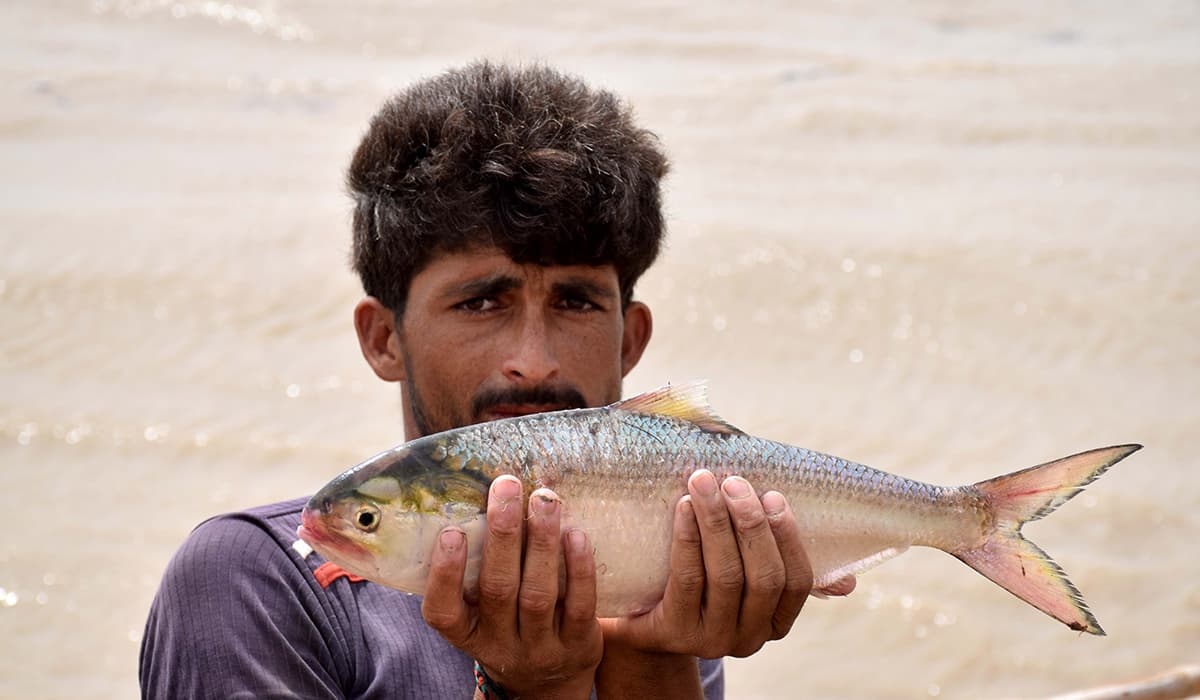
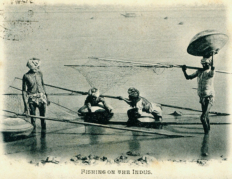
Palla fish (Tenualosa ilisha) from the river is considered a delicacy for people living along its course. Fishing is a significant economic activity in the region, particularly in major centers like Sukkur, Thatta, and Kotri in the lower Sindh course. The construction of dams and irrigation systems has further facilitated fish farming in the Indus River basin.
Economy
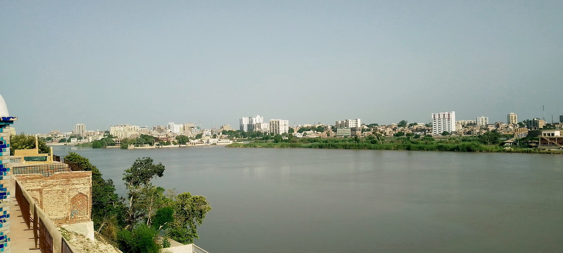
The Indus River plays a pivotal role in sustaining agriculture and food production in the Punjab and Sindh plains of Pakistan, serving as the primary water resource. Given the limited rainfall in the lower Indus valley, irrigation canals, initially constructed by the people of the ancient Indus Valley civilization and later expanded by the Kushan and Mughal Empires, have been crucial for centuries. The British East India Company introduced modern irrigation in 1850, overseeing the construction of an intricate canal network.
Among the significant infrastructure, the Guddu Barrage, stretching 1,350 meters, irrigates Sukkur, Jacobabad, Larkana, and Kalat, while the Sukkur Barrage covers over 20,000 square kilometers. Following the water control treaty signed between India and Pakistan in 1960, Pakistan secured a guaranteed water supply from the Indus River and its tributaries, Jhelum and Chenab, independent of upstream control by India.
The Indus Basin Project focused on constructing two main dams, the Mangla Dam on the Jhelum River and the Tarbela Dam on the Indus River, along with subsidiary dams. The Chashma-Jhelum link canal was built to connect the waters of the Indus and Jhelum rivers, extending water supplies to regions like Bahawalpur and Multan. The Tarbela Dam, standing 2,743 meters long and 143 meters high, supports irrigation and flood control through the Chashma Barrage and Taunsa Barrage, which also generates electricity. The Kotri Barrage near Hyderabad, 915 meters long, provides additional water for Karachi.
This extensive dam and irrigation network has facilitated the distribution of water resources to the Peshawar valley in Khyber Pakhtunkhwa. It forms the foundation for Pakistan’s substantial crop production, including cotton, sugarcane, and wheat, while also contributing to electricity generation for industries and urban centers.
People
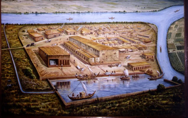
The people of the Indus Valley, historically associated with one of the world’s oldest civilizations, the Indus Valley Civilization (c. 3300–1300 BCE), thrived in the vast region encompassing present-day Pakistan and northwest India. These ancient inhabitants were known for their advanced urban planning, sophisticated architecture, and a system of writing that remains undeciphered, known as the Indus script.
The residents of major urban centers such as Harappa and Mohenjo-daro engaged in various occupations, including agriculture, trade, and craftsmanship. The cities exhibited a high level of organization with well-laid streets, drainage systems, and multi-story buildings. The people of the Indus Valley engaged in trade with other contemporary cultures, as evidenced by artifacts and seals found at archaeological sites.
The civilization’s decline, thought to be influenced by factors such as environmental changes, remains a subject of scholarly debate. Despite the civilization’s decline, the legacy of the people of the Indus Valley lives on through the rich archaeological discoveries that continue to provide insights into their culture, social structure, and technological achievements.
The Indus River holds sacred significance in Hinduism, with the Sindhu Darshan Festival being celebrated every Guru Purnima on its banks.
The ethnicities residing in the Indus Valley, spanning Pakistan and Northwest India, exhibit a higher level of ANI (or West Eurasian) admixture compared to other South Asian populations. This includes influences from Western Steppe Herders, indicating a history of prolonged and multi-layered migrations from the western regions.
Modern Issues
Indus delta
Originally, the Indus River delta received nearly all of the river’s water, boasting an annual flow of about 180 billion cubic meters and carrying 400 million tonnes of silt. However, since the 1940s, extensive dam construction, barrages, and irrigation projects have significantly altered the river’s dynamics. The Indus Basin Irrigation System, developed over the past 140 years, is now recognized as the world’s largest contiguous irrigation system. By 2018, these interventions had reduced the average annual water flow below the Kotri barrage to 33 billion cubic meters, with an estimated 100 million tonnes of silt discharged annually. The 2010 Pakistan floods were considered beneficial for the delta ecosystem, providing much-needed fresh water. However, further exploitation of river basin water is deemed economically unfeasible.
Some of the more key challenges include:
- Water Scarcity and Distribution: Increasing demands for water due to population growth, agriculture, and industrial activities have led to water scarcity in certain regions. Unequal distribution and competition for water resources among provinces and countries sharing the river exacerbate this issue.
- Dams and Infrastructure Development: The construction of dams and other infrastructure projects, although aimed at water management, can disrupt the natural flow of the river, affecting ecosystems, aquatic life, and the livelihoods of communities dependent on the river.
- Pollution: Industrial discharge, agricultural runoff, and untreated sewage contribute to water pollution in the Indus River. This pollution not only harms aquatic life but also poses risks to human health for those relying on the river for drinking water and irrigation.
- Climate Change: Changes in precipitation patterns, glacial melt, and overall climate conditions impact the Indus River. The reduction in glacier size, alterations in river flow, and increased frequency of extreme weather events pose challenges to water availability and management.
- Loss of Biodiversity: Habitat degradation, pollution, and altered water flow affect the biodiversity of the Indus River. Certain species, including the Indus River dolphin, face threats to their survival.
- Transboundary Disputes: The Indus River flows through multiple countries, leading to complex issues related to water-sharing agreements and disputes. Negotiations and cooperation are crucial for sustainable water management.
- Population Pressure: The dense population along the banks of the Indus puts pressure on the river for various needs, including agriculture, industry, and domestic use. Sustainable practices and population management are essential for long-term resource conservation.
Effects of Climate Change on the River
The Tibetan Plateau, home to the world’s third-largest ice store, is experiencing rapid ice melt and warmer temperatures. While this might initially benefit agriculture and tourism, it poses a severe long-term threat to the lifelines of the Indus River. Tibetan glaciers are receding at an unprecedented rate, with temperatures rising four times faster than the rest of China. The consequences include the expansion of lakes, increased risks of floods and mudflows in the short term, and the endangerment of water supplies in Pakistan in the long run. Experts fear a potential 50% reduction in the flow of the Indus River due to glacier melt caused by climate change, raising concerns about the survival of populations in the arid regions dependent on the river. U.S. diplomat Richard Holbrooke even speculated that declining water levels in the Indus could lead to global conflict, highlighting the critical importance of addressing climate change and protecting vital water resources.
Here are some of the effects of climate change on the Indus River:
- Glacial Melting: The Indus River is heavily dependent on glacial meltwater from the Himalayas and Karakoram ranges. Climate change has led to accelerated glacial melting, affecting the river’s flow patterns and increasing the risk of glacial lake outburst floods (GLOFs).
- Changes in Precipitation Patterns: Climate change can alter precipitation patterns, leading to changes in the timing and intensity of rainfall. This can impact the river’s water levels, potentially causing more frequent and severe floods or droughts.
- Temperature Rise: Increasing temperatures can affect the overall hydrological cycle, influencing evaporation rates and water availability. Higher temperatures may also contribute to the melting of snow and ice in the upper reaches of the river.
- Shifts in Ecosystems: Climate change can disrupt the ecosystems along the Indus River, affecting the flora and fauna that depend on its waters. Changes in water temperature and flow can impact aquatic life, including fish species.
- Sea Level Rise: The delta region where the Indus River meets the Arabian Sea is vulnerable to sea level rise. As global temperatures increase, melting ice caps and glaciers contribute to rising sea levels, which can lead to saltwater intrusion into the river delta.
- Extreme Weather Events: Climate change is associated with an increase in the frequency and intensity of extreme weather events, such as storms and hurricanes. These events can result in flash floods, landslides, and other hazards along the Indus River and its tributaries.
- Water Scarcity: Changes in precipitation patterns, increased evaporation, and higher temperatures can contribute to water scarcity in certain regions along the Indus River basin. This can have significant implications for agriculture, which relies heavily on irrigation.
Pollution
The Indus River faces significant pollution challenges that threaten both its ecosystem and the communities relying on its waters. Urban and industrial discharges, agricultural runoff, and improper waste disposal contribute to water pollution. Agricultural runoff introduces pesticides, fertilizers, and sediment, further compromising the ecosystem.
Factory emissions and industrial activities along the banks of the Indus River have significantly escalated water pollution levels, posing severe threats to both the river’s ecosystem and the surrounding atmosphere. The increased pollution has been linked to the alarming decline in the population of the endangered Indus river dolphin, with pollutants proving fatal to these aquatic mammals. In response, the Sindh Environmental Protection Agency has taken regulatory measures, invoking the Pakistan Environmental Protection Act of 1997, to mandate the closure of polluting factories situated near the river.
Pollution affects aquatic life, reducing biodiversity and harming fish populations. The demise of the Indus river dolphin has also been associated with harmful fishing practices, such as the use of poisonous substances to catch fish. It also impacts human health, leading to waterborne diseases and long-term health issues in communities along the river. To address this issue, the government has imposed a ban on fishing activities from Guddu Barrage to Sukkur. Furthermore, the Indus River ranks second among ten rivers worldwide responsible for approximately 90% of the plastic reaching the oceans, with only the Yangtze contributing more plastic waste. This highlights the urgent need for comprehensive measures to combat pollution and safeguard the health of the Indus River and its diverse ecosystem.
Flooding
The Indus River Basin is susceptible to flooding, and various factors contribute to this recurring challenge. Construction of dams, barrages, and irrigation systems since the 1940s has altered the natural flow of the river, impacting the quantity and sediment load of water reaching downstream areas. The Indus Basin Irrigation System, developed over the past 140 years, is the largest contiguous irrigation system globally but has also reduced water flow. As of 2018, the annual flow below the Kotri barrage had significantly decreased.
2010 Floods
In 2010, the devastating Pakistan floods were considered both a natural disaster and a relief for the ecosystem and population of the river delta. The floods brought much-needed fresh water, alleviating the ecosystem and aiding the population. However, managing the balance between addressing flooding concerns and ensuring a sustainable water supply for the ecosystem remains a complex challenge for the Indus River Basin. The construction of dams and irrigation works has altered the hydrological dynamics, and careful water management strategies are essential to mitigate both floods and water scarcity issues.
The severe flooding gradually moved southward along the Indus River, affecting northern regions before reaching western Punjab and the southern province of Sindh. In western Punjab alone, approximately 1,400,000 acres (570,000 ha) of cropland were destroyed. By early September 2010, the calamity had claimed the lives of over two thousand people, and more than a million homes had been obliterated since the onset of the flooding. The 2010 Indus River floods stand as one of the most devastating natural disasters in the history of Pakistan.
2011 Floods
The 2011 Sindh floods unfolded in mid-August 2011 during the Pakistani monsoon season. The catastrophe resulted from heavy monsoon rains affecting Sindh, eastern Balochistan, and southern Punjab. The floods inflicted significant damage, claiming an estimated 434 civilian lives and impacting 5.3 million people, with 1,524,773 homes affected.
Sindh, renowned as the “breadbasket” of Pakistan due to its fertile lands, bore the brunt of the floods, causing extensive harm to the local agrarian economy. Over 1.7 million acres (690,000 ha; 2,700 sq mi) of arable land were submerged, exacerbating the agricultural challenges. The torrential monsoon rains, unprecedented in scale, led to severe flooding across 16 districts of Sindh. The 2011 Sindh floods added to the woes of the region, following the devastating floods that occurred the previous year.
2022 Floods
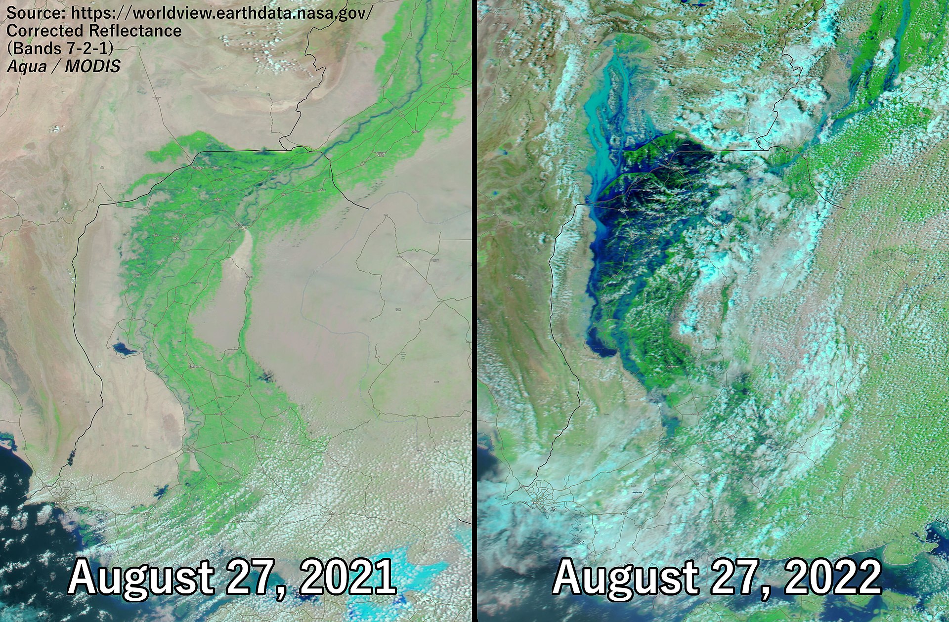
The year 2022 brought catastrophic floods that transformed the Indus River into an expansive lake spanning 100 km (62 mi). In a remarkable display of resilience, the residents of Johi and Mehar protected their towns by creating protective ring bands. The city of Jacobabad, known as the world’s hottest, faced dire conditions, with over 40,000 people residing in makeshift shelters and limited access to food, resulting in 19 reported deaths from the flooding as of August 31. Floodwaters submerged around 300 villages in the Dadu District, and Lake Manchar’s overflow triggered drainage efforts in September 2022. The aftermath of the disaster has raised significant health concerns, with the Sindh provincial government confirming 588 cases of malaria, 10,604 suspected cases, 17,977 cases of diarrhea, and 20,064 cases of skin diseases as of September 16, 2022. Since July 1, a staggering 2,300,000 patients have received malaria treatment in field and mobile hospitals, reaching a peak of 90,000 diarrhea cases reported in a single day on September 1.
Barrages, Bridges, Levees and Dams
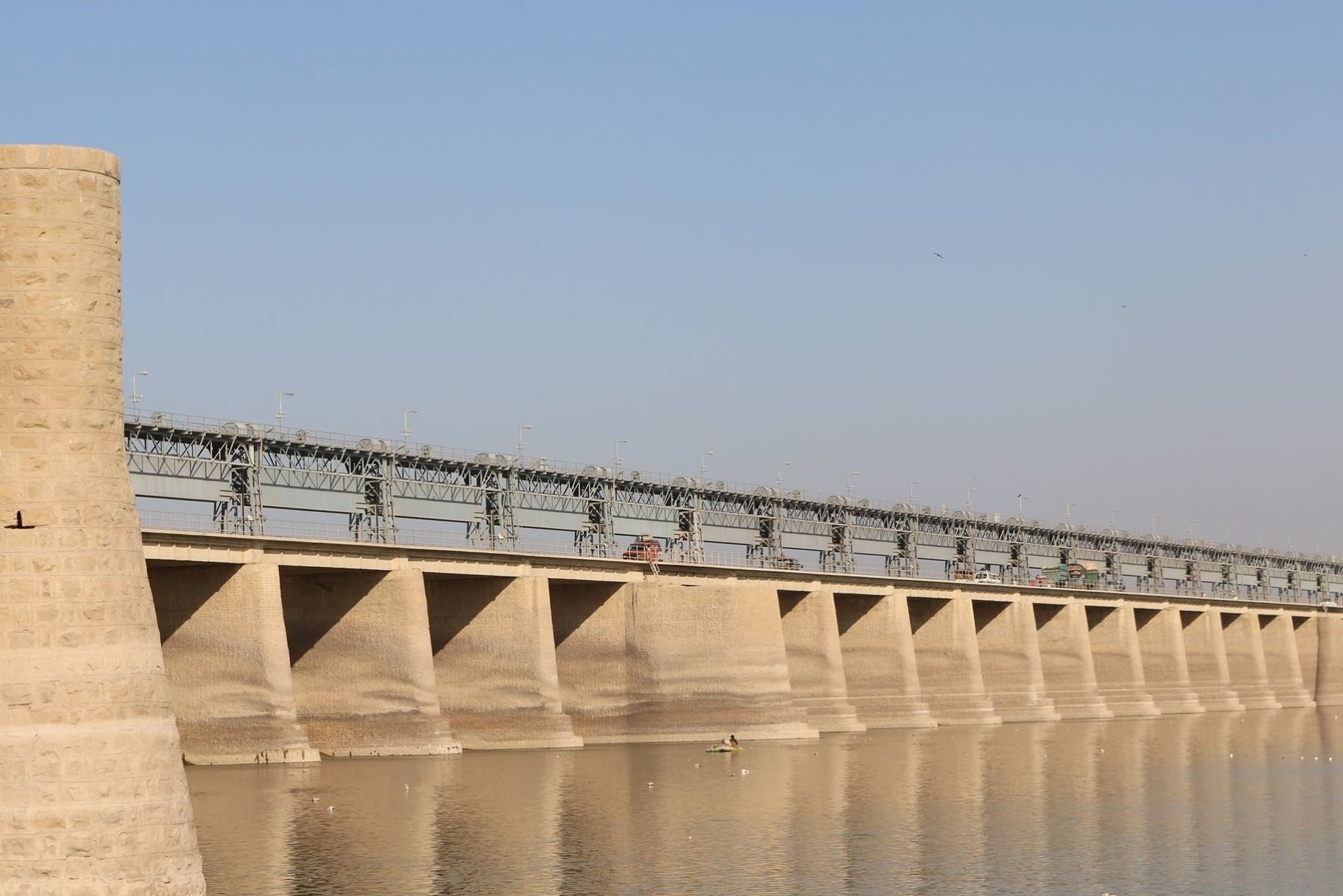
In Pakistan, there are currently six barrages strategically placed along the Indus River to manage its flow and resources: Guddu Barrage, Sukkur Barrage, Kotri Barrage (also known as Ghulam Muhammad Barrage), Taunsa Barrage, Chashma Barrage, and Jinnah Barrage. Additionally, there are plans for a new barrage named “Sindh Barrage” to serve as a terminal barrage on the Indus River. Several bridges span the Indus, including Dadu Moro Bridge, Larkana Khairpur Indus River Bridge, Thatta-Sujawal Bridge, Jhirk-Mula Katiar Bridge, and the recently planned Kandhkot-Ghotki Bridge.
To protect the left bank of the Indus River in Sindh province from flooding, an extensive system of levees, approximately 600 km in length, has been constructed. The right bank is also leveed from Guddu Barrage to Lake Manchar. However, the construction of levees has led to rapid aggradation of the river over the past two decades, resulting in breaches upstream of barrages and the inundation of large areas.
Notable dam projects on the Indus River include Tarbela Dam, a crucial water reservoir in Pakistan, and the controversial Kalabagh Dam, which is still under construction. Pakistan is also in the process of building the Munda Dam to further manage water resources in the region.
In addition to the existing barrages on the Indus River in Pakistan—Guddu, Sukkur, Kotri, Taunsa, Chashma, and Jinnah—a new terminal barrage named “Sindh Barrage” is planned to enhance water management along the river. These barrages play a crucial role in regulating the flow of the Indus, ensuring water availability for agriculture and other needs in various regions. The river is further crossed by essential bridges such as Dadu Moro Bridge, Larkana Khairpur Indus River Bridge, Thatta-Sujawal Bridge, and Jhirk-Mula Katiar Bridge, contributing to the connectivity of communities on both banks. A recently planned Kandhkot-Ghotki Bridge underscores the continuous infrastructure development in the area.
To mitigate the risk of river flooding, an extensive levee system spans approximately 600 km along the left bank of the Indus River in Sindh province. Simultaneously, levees have been implemented on the right bank, extending from Guddu Barrage to Lake Manchar. However, this protective measure has led to rapid aggradation of the river over the last two decades, resulting in breaches upstream of barrages and the subsequent inundation of large areas, highlighting the complex challenges in managing the river’s dynamics.
The Indus River is home to significant dam projects, including the Tarbela Dam, a key reservoir providing water storage for agricultural and domestic purposes. The Kalabagh Dam, despite being a subject of controversy, remains under construction, while the Munda Dam is part of Pakistan’s ongoing efforts to enhance water resource management and address the country’s growing water needs. These dam projects contribute not only to water storage but also to hydroelectric power generation, supporting various sectors of Pakistan’s economy.
Read Also:
- List of Airports in Pakistan
- Different Types of Forests in Pakistan
- Sargodha; A Breif Overview Of Its History, Geography, & Economy

📍 SEO & Content Strategist | Expert in Current Affairs, History, Geography & Education Blogs | Digital Marketing Specialist
Muhammad Talha Mehmood is a seasoned digital marketing specialist, SEO expert, and content strategist with over six years of experience in creating high-impact, research-driven content. As the driving force behind Globaleak.com, he delivers in-depth articles on current affairs, history, geography, and education, helping readers stay informed with accurate, well-researched insights.
🔹 Expertise & Achievements:
✔ SEO & Content Strategy: Specializes in creating authoritative, high-ranking content that aligns with Google’s EEAT guidelines.
✔ Research & Analysis: Covers historical events, geopolitical trends, and educational topics with in-depth research and expert insights.
✔ Proven Track Record: Has successfully worked with global clients, delivering content that enhances brand trust, audience engagement, and search rankings.
✔ Academic Excellence: Holds an MBA in Marketing from IBA, University of the Punjab, and a B.Com (Hons) from Hailey College of Commerce.
✔ Industry Experience: Started his career with Packages Limited, trained under PITB’s E-Rozgar Program, and later became a Team Leader & Trainer at Emenac Group of Companies.
🚀 Passionate about creating impactful content, Muhammad Talha ensures every article is insightful, engaging, and value-driven.
📧 Email: talhamehmood34@gmail.com
🔗 LinkedIn: linkedin.com/in/talhamehmood-34